Tuesday, July 24, 2012

Helsinki by sea


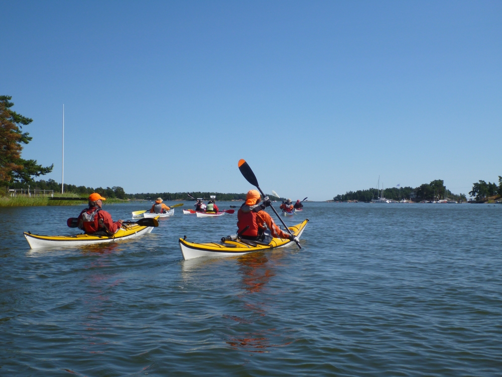
Kayak trip to Helsinki archipelago... Hmm, it was an idea during the winter time and finally it realized. The starting point was Suomenoja guest harbor at Espoo and the trip headed towards Helsinki. Unfortunately the length of the trip was only two days, which on the other hand limited the number of places to visit. Therefore there are lots of places still to be seen and visited for other trips to Helsnki area in the future...

Suvisaaristo, Espoo

I have to admit Helsinki is beautiful city from the sea. Small islands make the paddling interesting and there's always protection against the wind. On the other hand there are lots of boats, ships and other vessels on the sea, which makes the paddling a bit more challenging.

Swimming snake

It's amazing how many kayaking clubs have their premises just in the center of Helsinki. Merimelojat (MeMe), Helsingin Kanoottiklubi (HKK), Helsingin Melojat (HeMe) and Melaveikot (MeVe). Plus few more in Espoo... The possibilities for kayaking in Helsinki area are extremely good.

Camping shore

This wasn't my last kayak trip on Helsinki area...


Monday, July 9, 2012

Wet, wet, wet

Waiting for the start

There's nothin' new under the sky. Wet, wet and wet! This weekend sport exercise was 3 km open water swim at Vansbro, Sweden. At the beginning I knew already I'm going to be wet when swimming, but like on every sport event earlier this year I have had a chance to enjoy rainfall, Vansbrosimningen was not an exception.

Onto water

I jumped onto a Vanån - river at 12:00 local time and felt the coolness of the water, plus 17 degrees. Immediately after start my body was getting warm and swimming felt OK with wetsuit. However it was a bit strange to swim in a big group of other swimmers and having occasional contact to others.

On a start

Soon after half-way it started to rain heavily and raindrops hit the surface of the water powerfully. Fortunately visibility was still sufficient and rainfall didn't hamper swimming.

1 km behind, 2 km still to go

The last few hundred meters fighting against upstream were long and tough, but I slapped my hand onto a finish line at faster time than I had imagined. Now 3/4 of Svensk Klassiker is behind. It's time to switch cycling and swimming onto running exercises...

At finish!

Monday, June 25, 2012

Midsummer paddling on Baltic Sea

On the shore of Hailuoto

The first paddling trip this year was selected according the lighthouses still not conquered. The two northernmost lighthouses, where I had not yet been visited were Marjaniemi and Ulkokalla. When weather forecast for the Midsummer was relatively good, the destination was locked and on Thursday evening after 5 hours drive, tent was pitched on the shore in Rahja, near Kalajoki town.

Approaching Ulkokalla lighthouse island

Ulkokalla is located roughly 18 km out of the shore on the southernmost part of the Bay of Bothnia. All in all during Friday we managed to paddle to Ulkokalla lighthouse island and back to the shore, alltogether 37 km. As this was my first trip this year, I was feeling paddling in my muscles.

On Keskiniemi daymark

The next day, Saturday, was sunny as well and there were only mild wind expected. We started paddling from Marjaniemi and headed towards NE and Keskiniemi daymark. Returning back to Marjaniemi and it's lighthouse after 2 hours paddling and 12 km was quite enjoyable.

Marjaniemi lighthouse

On the way back to our nightstay on Raahe, we visited Laitakari daymark east from Hailuoto island. It was only 10 km paddling, which took 1,5 hours. The queue for the ferry was long one and we had to wait over 1 hour for boarding on the ferry to the mainland.

Laitakari daymark

There were still one daymark still to be visited, Tasku on the archipelago of Raahe. Early Sunday morning our kayaks were on the water and 8 km short paddling trip took us to Tasku and back.

Tasku daymark

Altogether 67 km paddling during Midsummer took us to 2 lighthouses and 3 daymarks. Currently I have visited already on 33 lighthouses by paddling and the objective of this year (2 new lighthouse visits) has been achieved! Great!

Break at Laitakari

Monday, June 18, 2012

Vätternrundan + Jukola

At starting line of Vätternrundan

The weekend was by far the toughest one during this year. I had had only 5 days to recover from Pirkan lenkki (217 km) cycling event when I was again at starting line of cycling event. This time at Motala, Sweden, where the start and finish are located for cycling around the Vättern-lake (Vätternrundan).

I had successfully completed the 3-day high carbohydrate diet by eating pasta, pasta and pasta... Therefore I had done everything I was able to fulfill my carbohydrate storage and was ready to start for 300 km cycling around Vättern.

The Friday evening was clear and beautiful and I had decided to start as early as possible. My starting time was 19:42 and I thought I need more or less 14 hours to finish, i.e. reaching the finish line roughly 10AM in the Saturday morning. I was wearing only short cycling shirt and short cycling trousers, but nearly everybody else had windproof jackets and long trousers...

Beautiful weather before the start

Soon after start the sun was setting and it was getting cooler and cooler. I was feeling pretty OK at the beginning, but very soon I realized my choice of clothing was not enough. When I stopped at Gränna service station after 80 km cycling I put on extra sleeves to my arms and windproof vest.
At Jönköping service station after 107 km I added extra legs to keep warm when temperature was still going down during the night. It was almost midnight and I was ahead of my initial schedule nearly one hour! But the  most difficult section started after the midnight. The next 2-3 hours at dark and cold fighting against tiredness was mentally tough. I reached Hjo service station at 177 km at 2:33AM and thought it's not getting any worse. But I was wrong!!!

Soon it started to rain and it rained until I reached finish line at 7:56AM. With rain the wind increased and temperature dropped. It was extremely cold and I was totally wet for 4-5 last hours. According the Vätternrundan pages the harsh conditions caused record number (2200) of cyclist to discontinue the race. I managed to cycle to finish but I was nearly hypothermic.

Approaching Gränna service station

All in all I was using only 11,5 hours for Vätternrundan and it felt really good. But it wasn't all for this weekend. Jukola orienteering relay was held in Vantaa next night. I had already spent one sleepless night for cycling 300 km and in the evening I was flying from Stockholm via Riga to Helsinki, where I arrived on Sunday night at 1AM. I took the taxi to the Hakunila competition center and had a chance to sleep for few hours before I had to start my leg.
I was running the 7th leg (15 km) and as expected my legs were extremely tired already at the beginning. Somehow I managed to focus and found control points easily and after 2,5 hours I was happily at the finish line. It started to rain just hour before and again I was totally wet.

At the finish there were problems with my EMIT chip, they couldn't read it and therefore I was demanded to wailing wall. Fortunately I had used the EMIT control slip and they found the punching marks from each and every control point. Otherwise our team would have been disqualified. What a relief !!!

EMIT control slip saving the disqualification of our team

This week I'm just resting and relaxing. Well, continuing my swimming exercises for the next Svensk Klassiker event at July, which is 3 km open water swimming.

Sunday, June 10, 2012

Pirkan lenkki 217 km

After finish line, tired but happy

This Sunday was not the sunniest day, but despite of that there were Pirkka cycling loppet scheduled for today. This was the first time I was attending the longest route, 217 km. When gathering under the startline at 7 AM, raindrops were falling and the first kilometers were cycled at rain.

The Minister for Europe and Foreign Trade, Alexander Stubb, was starting for his 217 km as well.

After 84 km I stopped to eat a decent lunch (soup and bread) at Komi service station, which gave extra energy for the rest of the route. There were endless line of uphills and downhills on the way around Näsijärvi lake. The second rain shower was at the end of the loppet and when crossing the finish line at the time of 9 hours I got totally wet again.

For next couple of days I'll be concentrating of recovery and charging fully my energy storage...

Monday, June 4, 2012

Paddling season open

Although the temperature of water is still a bit chilly, paddling season for this year has been opened with a paddling tour to Saarikylät and paddling course for beginners.

Paddling at Saarikylät


There were 11 participants in a Saarikylät paddling tour with 2 hour canoe trip. Sun was shining, but the level of water was extremely high and the platform to start the paddling was totally under the water.

Beginners paddling course at Näsijärvi

Couple of days after leading a canoe trip I was one of the guides at beginners course. The course was fully booked with 14 participants. All in all it's sure I don't have possibilities to paddle as much as last summer, but hopefully I have some time at midsummer to do a short paddling trip to the Baltic sea.

Wednesday, April 25, 2012

UKK National Park at April

Skiing at Vongoiva fells

7 great days in the middle of April at UKK National Park ! This was our second winter hiking trip this winter. The target for the hike was selected already long time ago and based on the experiences two years ago, week #16 was expected to be the best week for it. And sure it was !!! We had 6 beautiful days out of 7 total days spent outdoors.

Scenery on top of the Fells

We started our hike from Raja-Jooseppi, close to Russian border, and our aim was to visit as south as Vongoiva Fells. The first day with heavy backpacks was planned to be easy one. We crossed Lutto-river and followed Suomu-river until Pahaoja-river, from where we started climbing towards Jyrkkävaara wilderness hut. On the way to wilderness hut some of us saw a lonely wolf running just few hundred meters ahead of us.

Footprints of wolf

Second day was sunny and we decided to head directly to Anterinmukka wilderness hut over the Kuikkapää Fells. It was tough climbing at the beginning, but the scenery was amazing. All in all after 24 km skiing we reached wilderness hut and enjoyed warm and sunny evening with sauna.

Kuikkapää behind, soon starting descending to Anterinmukka

3rd day was even more beautiful than the previous ones. Our plan to visit Vongoiva Fells at today was perfect timing. The sun was shining and there were absolutely no wind. The day was tough however, 30 km with 1000 meter ascending during the day. But it was worth of it. Vongoiva and Reututunturi Fells are just amazing ones. The downhill from Reututunturi down to Anterinjoki-river was like telemark at powder snow between small birches.

Anterinmukka sauna-cabin

The Wednesday was the only day with snowfall, low visibility and moderate wind. Today we didn't climb to the Fells, but instead skied on the gorges like Hammaskuru-gorge to Hammaskuru wilderness hut and furthermore to Luirojärvi wilderness hut. The day was long 30 km, but the sauna was waiting us at Luiro as well. Hammaskuru gorge was beautiful with all packed snow at the bottom. At Hammaskuru we saw footprints of wolverine and when we met a guy at Hammaskuru hut, he saw us from his camera a photo of wolverine, amazing !!! 

Sun was shining at Hammaskuru through thick clouds

On 5th day we started to ski back towards north and headed from Luiro to Sarvioja and further to Jyrkkävaara hut.

At Jyrkkävaara

6th day was a bit shorter skiing day than previous ones. We skied over the hills to Kiertämäjärvi hut and visited on the Finland - Russia frontier zone.

At frontier zone

Last day skiing was easy one next to frontier zone and via the bridge over the Lutto-river back to the car. All in all within 7 days I was skiing 160 kilometers and saw a bunch of eastern part of UKK National Park. UKK National Park is one of the biggest and last wilderness areas at western Europe.

Our team

The route for this hike can be found from here.