Wednesday, July 27, 2011

30. day 62 km (in total 1301 km)

<Hietakalla, Ii - Röyttä, Tornio>

Final few hundred meters at Tornio

Finally at Tornio ! It was a long day, but now I'm extremely happy after finishing coastline paddling. It took 30 days as I expected in half-way. The last day was like the first one, sunny with mild or non-existent wind. Just great paddling day.

Keminkraaseli lighthouse

During the day we visited Ykskivi daymark and Keminkraaseli lighthouse islands.

Ykskivi daymark

The day was full of long crossings and long last kilometers to Tornio...

Tired but happy after 30 days

Tuesday, July 26, 2011

29. day 47 km (in total 1239 km)

<Hietakari, Haukipudas - Hietakalla, Ii>

Weather forecast was giving a warning of strong wind up to 14 m/s today, but the wind would calm down in the evening. Therefore we didn't had any rush to start paddling today, instead took easy and slept long. We enjoyed sunshine at the beach we were camping and followed the actual wind values of Marjaniemi, one of the closest weather stations. It was steadily blowing 13 m/s, but after 2 PM wind was starting to decrease. We had lunch before we headed to the sea at 4 PM.

Direction was straight to north and we followed the few islands on the way. We quickly visited Röyttä, which is an island in community Ii and having guest harbor. Then continuing to the north. Just before midnight we reached Hietakalla and pitched the tent and had quick supper before going to sleep.

Sunday, July 24, 2011

28. day 36 km (in total 1192 km)

<Varessäikkä, Siikajoki - Hietakari, Haukipudas>

There were thunderstorms in the morning all around our camping place. It was raining and we had to wait until 10 AM before we dared to start to paddle 9 km crossing to Hailuoto island. We managed to reach Hailuoto and started the second crossing, which was around 12 km. Immediately we had to reroute and paddle closer to shore, because one of those thunderstorms was getting closer. Barely we managed to go ashore and get some shelter, before the storm hit. It took 1,5 hours and then we decided to start the second crossing again. During the crossing we got heavy rainshowers and were completely wet when arrived to ferry harbor at Hailuoto.

We had pizza for the lunch at local cafe, although it was already at 4 PM and decided to continue further. What a mistake! Soon we started another storm came and we were already paddling 9 km crossing to next islands. The wind increased, waves were getting bigger and bigger, rain showers were so intense that visibility was lost. It took from us all the focus and skill to survive safely 9 km crossing in such conditions. I really don't want to experience similar conditions anymore...

Now we are at Hietakari having well deserved rest after awful day.

27. day 49 km (in total 1156 km)

< Raahe, Raahe - Varessäikkä, Siikajoki>

Paddling continued and we had all the day headwind 4-5 m/s from NE. First leg from Raahe to Tauvo was about 3 hours, after which we landed on the beach near Tauvo lighthouse. Day was sunny, but windy. We continued and passed Siikajoki delta, which was extremely shallow area and reached windmills at Varessäikkä.

Tauvo lighthouse

We tried to continue towards Oulu, but had to return back to Varessäikkä due to shallow waters. It was practically impossible to paddle. We need to do crossing to Hailuoto tomorrow to continue towards north and Tornio.

Friday, July 22, 2011

26. day 0 km (in total 1107 km)

Today is the first rest day during this trip. The rest day is more than welcomed now. We have had quite a long paddling days and stretches within 5 days. Getting familiar with Raahe, doing laundry and some other mandatory tasks is on the schedule for today. Let's continue tomorrow...

Thursday, July 21, 2011

25. day 62 km (in total 1107)

<Kalajoki, Kalajoki - Raahe, Raahe>

We had a plan to reach Raahe today and so we did! When we arrived to Kalajoki beach we had a rest of 3 hours and then started to paddle at 11 PM during the night. Weather forecast was expecting stronger headwind for this afternoon and therefore we decided to paddle as far as we could during the night on the good tailwind. After 4 hours paddling we pitched the tent at 3 AM on a beach at Pyhäjoki.

At Raahe

We had a sleep until 9 AM and started towards Raahe at 10 AM. 7,5 hours later we arrived to Raahe on moderate headwind from NE. We are staying overnight at my relative's cottage with all the luxury !!! Electricity, running water, sauna and bed. I can't express myself how good it feels now. I'm grateful to stay here and enjoy all the facilities. Thanks from our behalf!

Iso-Kraaseli daymark

Just when arriving to Raahe, we visited on Iso-Kraaseli daymark. Now we are going to the city to have supper and buy some food.

Wednesday, July 20, 2011

24. day 53 km (in total 1045 km)

<Poroluoto, Kälviä - Kalajoki, Kalajoki>

Fine paddling day again. Sunshine, mild tailwind and nice sandy beaches.

Lunch break at Ohtakari, Lohtaja

We reached Kalajoki sand beaches today and set a camp on a beautiful beach. We had one mistake on the route selection during the day and therefore the day was longer than expected.

Kalajoki beach for 3 hours rest

23. day 46 km (in total 992 km)

<Mässkär, Pietarsaari - Poroluoto, Kälviä>

1000 km milestone is getting closer and closer. Now we are nearby Kokkola city in Poroluoto island. There are "wilderness" hut and sauna located at this island. The cottage and sauna is owned by the city of Kokkola and they are meant for recreational usage. I don't know if wilderness is correct word for this cottage, because it's located close to the city, "wilderness hut" is more suitable word for the huts in Lapland.

Poroluoto hut

We were sleeping quite late this morning and waiting for the better weather. It was raining during the night and the morning when low pressure area was passing by. Therefore we started after 12 AM on a nice tailwind (4-6 m/s from SW). There were many route options to choose for this day and we selected the most straightforward and shortest one.

The first part in the morning was nice through the maze of islands between Pietarsaari and Kokkola. The afternoon stretch was again crossings between islands and we arrived to Poroluoto about 8 PM. Paddling was easy today and it would have been possible to continue, but the camping places are few from now on. So we decided to stay overnight here and enjoy sauna on a second evening in a row. What a luxury!

Monday, July 18, 2011

22. day 35 km (in total 946 km)

<Storskäret, Uusikaarlepyy - Mässkär, Pietarsaari>

During the night wind was turning to blow from SE and I woke up many times to check if the water on the shore would still be lower than our tent on the beach. Fortunately water level didn't raise up to tent and we started against the wind this paddling day.

Amazingly tasty fresh trout plate

There were still one longer crossing towards mainland, which went well despite of increased wind speed. On the way towards Pietarsaari we visited Hällgrund daymark, where we had lunch after 3 hour paddling. Delicious pasta :)

Hällgrund daymark

Paddling felt quite tedious today and finally we arrived to second daymark island of today : Mässkär. We decided to stay here overnight and had the possibility to have sauna and wash ourselves, absolutely great feeling to have sauna within 1 week. It was a superb surprise when we ordered supper at local cafe. The chef had prepared meal from fresh trouts, which was the best a'la carte dish I have had during this paddling trip. Just amazing meal! I recommend everybody to have lunch/supper at Mässkär.

Mässkär daymark

21. day 53 km (in total 911 km)

<Korsören, Mustasaari - Storskäret, Uusikaarlepyy>

This was the day of lighthouses, daymarks and long crossings on open sea. It all started at 15 km crossing from last night's camping place, Korsören to lighthouse island Ritgrund. Fortunately weather was fine, sunny and no wind. It took 2,5 hours to reach the lighthouse.

Ritgrund lighthouse

We had 1 hour break at Ritgrund after which we had another 15 km crossing onto a Mikkelinsaaret, which is part of Kvarken archipelago, the world heritage. So after 5 hours paddling we had a lunch at Mikkelinsaaret. On the northern point of islands there are old coast guard station, which is nowadays in recreational usage. There are cafeteria, sauna, etc.. on the area. We decided to eat in the cafe and had delicious elk-lamb pot with local bread.

Stubben daymark

2 hours went fast and it was hot, when sun was shining and there were no wind. Finally we decided to continue and next we had 20 km crossing to the Stubben lighthouse and daymark, which are located on islands next to each other.

Stubben lighthouse

All in all it took 8,5 hours paddling and 53 km, when we finally arrived to beautifully sand beach on the island having Stubben daymark as well. You bet we were hungry after such long paddling day. Tomorrow we are heading towards Pietarsaari...

On the beach after supper

P.S. Fortunately Minna has camera with her, because mine went broken. Therefore I can attach photos still on the blog.

Sunday, July 17, 2011

20. day 56 km (in total 858 km)

< Moikipää, Korsnäs - Korsören, Mustasaari >


It had been raining during the night, but morning were cloudy without raindrops. I started at half past eight and headed towards north. The wind was mild and coming from SW, which was excellent for long crossings between Moikipää and Raippaluoto. I felt quite strong today due to shorter day yesterday and paddled 3-4 hours stretches. I had lunch after 12 AM and it started to rain heavily. I was completely wet and it lasted roughly 3 hours.The visibility was poor, but I managed to reach Raippaluoto harbor at 4:30 PM. It was great to see magnificent Raippaluoto bridge and realize I made it.


During the heavy rain the minigrip bag in the pocket of life vest was leaking and when I was trying to take a picture of bridge my camera was not functioning at all. It was completely wet. I have tried to dry it up, but without success. So it means this blog will be without photos from now on.


Minna, who was paddling with me during mid-summer 3 days joined again from Raippaluoto harbor and it is nice to have company. Paddling alone is really lonesome activity.

Friday, July 15, 2011

19. day 35 km (in total 802 km)

<Horsstenarna, Närpiö - Moikipää, Korsnäs>

The day was sunny, but windy. Wind was coming from east and in gusts I had to paddle with all my power. I tried to find a place to have lunch, but there aren't actually good spots in this part of coast. All shores are rocky or there are houses / cottages. Therefore I decided to have lunch at Moikipää, where I landed next to restaurant at 2 PM. The pizza tasted heavenly delicious. I decided to camp nearby and rest the rest of the day. Tomorrow I'll try to reach Vaasa, hopefully wind is not that strong anymore.

 Rocky camping spot in Horsstenarna

18. day 60 km (in total 767 km)

<Norrgrund, Kristiinankaupunki - Horsstenarna, Närpiö>

Härkmeri daymark

Wind was blowing all the night and I didn't start until 10 AM. Just a couple of kilometers away were small island, where Härkmeri daymark was located. I headed first to see the daymark before turned my kayak towards Kaskinen. The morning was nothing but easy. Tailwind, waves and my body was complaining all the time.

Kaskinen full of old wooden houses

After tedious 5 hour paddling I arrived to beautiful Kaskinen city and I was ready to quit paddling totally. I took a long lunch break and did some shopping. After 2 hours I was ready to continue again.

Spot for the tent in Norrgrund, from where I left this morning

The afternoon paddling were much better and the wind was decreasing towards evening. Therefore I stretched my day and surprisingly I was paddling until Närpiö community. It seems I'm following the schedule and route of Jarkko, Jukka and Pasi... However I'm going to have shorter day tomorrow, so I'm not going to paddle to Vaasa tomorrow.

The current place is maze of shoals and rocks. I haven't seen such a place ever before. This is just amazing...

In the middle of rocks

Thursday, July 14, 2011

17. day 44 km (in total 707 km)

<Merikarvia, Merikarvia - Norrgrund, Kristiinankaupunki>

Sunset at Norrgrund, Kristiinankaupunki

Yesterday when I was arriving to Merikarvia it was already blowing 10 m/s from west and wind was increasing all the time. During the night and the morning it went up at 12 m/s and therefore I decided to wait for the wind to calm down a bit.

I had the breakfast and lunch at camping place and when the wind seemed to ease a bit according the forecast I headed onto a sea at 2 PM. Wind was from NW and I struggled with 6-8 m/s tailwind first couple of hours. Fortunately weather was calming down in the evening and I managed to reach southern islands of Kristiinankaupunki. The waters are shallow and shoals are everywhere, this day was one of the nastiest I have had during my paddling trips. I had to be focused and alert all the time due to a strong wind, waves, rocks and shoals. I really don't like to paddle on the waters of Merikarvia...

Shoals and rocks and waterway zigzagging between them

Now I'm listening the sound of the wind and waves in my tent. I hope I'll have good sleep after tedious day.

Tuesday, July 12, 2011

16. day 44 km (in total 663 km)

<Outoori, Pori - Merikarvia, Merikarvia>

Yesterday's long paddling stretch and late bedtime made me start a bit later today. I was feeling on my body yesterday still in the morning. It had rained during the night and it seems weather has changed now. It feels colder and the wind is increasing and turning to west / north west, which is not too good direction for me now.

Ryssäntorni daymark at port of Pori

Anyhow I grabbed my paddle at 10 AM and headed towards port of Pori. I visited Ryssäntorni daymark at the harbour of Pori. The sea is more shallow and there are rocks and shoals everywhere. When the wind increases it will make the waves bigger when they reach the shoal. Therefore the whole day was really fighting against western wind and waves coming from the open sea onto a shallow shore. I was happy when I finally arrived to Merikarvia camping area at 7 PM. It was nice to have first shower within 3 days :)

Humor from Pori. It is forbidden to bike on shoals...

15. day 73 km (in total 619 km)

<Lyökki, Uusikaupunki - Outoori, Pori>

Halfway passed today! At the evening I passed Luvia, which is on a halfway from Virojoki to Tornio. It took 15 days and thus it would indicate it would be possible to complete Finnish coastline in 30 days...

Santakari daymark

I started early at 7:30 AM and the first 3 hours paddling went on a 5-6 m/s tailwind (SW). On a way to Kylmäpihlaja lighthouse I visited Santakari daymark, when it was conveniently just on my route. It was only 1 hour paddling from Santakari to Kylmäpihlaja and I arrived nicely at 12AM at lunch time.

The harbour of Kylmäpihlaja lighthouse island 

Lunch was extremely delicious with creamy fish soup and fish plate with different kind of fishes, like salmon, baltic herring, smoked whitefish, etc... I recommend the buffet lunch if you are planning to visit this lighthouse.

Fish soup and fish plate with local bread & salad

Because the weather was so fine and I felt comfortable with paddling I decided to have a long stretch today. I was paddling altogether 11 hours and arrived to Outoori island in Pori roughly at 9:30 PM. This camping place was familiar to me from my earlier trips on this area. Really nice spot and superb sunset!

Arriving to Outoori

Monday, July 11, 2011

14. day 52 km (in total 546 km)

<Mussalo, Taivassalo - Lyökki, Uusikaupunki>

At Jere's cottage

Coastline paddling continues again. After Kökar trip I was invited by Jere to the summer cottage in Kustavi. It was great to spend marvellous summer evening with friends eating well, having sauna and swimming in the sea. Thanks a lot, Jere.

Lyökki daymark

Due to the late bedtime yesterday I didn't had any rush to start paddling again. Just after 12 AM I started from the camping area of Mussalo, where I stopped paddling one week ago. The weather was fine, sun was shining and wind was blowing 5-6 m/s from SW. Paddling felt easy and I continued as far as Lyökki island in Uusikaupunki. Lyökki has the oldest daymark (built 1757) of Finland.

Sunset at Lyökki

Saturday, July 9, 2011

Paddling in Kökar archipelago

Paddlers of Vihuri at Gustaf Dalen lighthouse

The week of paddling in Kökar archipelago is over. 5 members of Vihuri paddling club from Tampere was participating on this sea paddling trip to Åland. Sun was shining nearly all the time and the wind was gentle and allowed us to paddle on each day altogether 150 km.

Paddling on a calm sea

We managed to visit on 2 lighthouses: Kökarsören and Gustaf Dalen. Bogskär daymark was on our way back from Gustaf Dalen to Husö island.

We enjoyed the hospitality of Monica and Christer, when they offered us a night at their summer cottage. Sleeping two nights at bed, having sauna, swimming and making pancakes on a open fire at cliffs with friendly and enjoyable company were more than we could expect. I would like to send my warmest greetings to Monica and Christer and thank on behalf of all of us. Great people in a lovely archipelago.

Christer and Monica

Friday, July 1, 2011

13. day 32 km (in total 494 km)


<Montti, Rymättylä - Mussalo, Taivassalo>

I woke up at night many times, because of powerful thunderstorm was passing by. It was raining heavily and storm was loud, couldn't sleep too much. Fortunately it didn't last till morning and I was able to eat breakfast and pack my stuff in a sunshine. Although weather forecast was warning about thunderstorms and therefore I decided to choose a route very close to the islands, just in case I would need to land if thunderstorm would be hitting during my paddling.

I had lunch break at Velkua after 3 hours paddling in a sunshine and mild tailwind. Last stretch to Mussalo camping area took roughly 3 hours as well. Now I'm going to have 1 week break from Finnish coastline paddling, because tomorrow I'm going to head onto a Kökar archipelago at Åland. I'm leading a paddling trip of paddling club Vihuri, which is active 400+ member club in Tampere. The group of paddlers are going to paddle 1 week on the waters of Kökar and I'll be continuing my coastline paddling trip on 9th or 10th of July from here (Mussalo). Stay tuned...

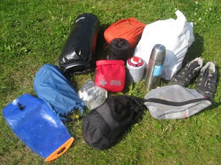
Let's continue about the equipment I'll have with me.

In a cockpit I'll have 10 liter water-bag just behind my seat and sponge to take small amount of water away from the cockpit. Spraydeck covers the cockpit and prevents water to get in to cockpit. I'm wearing life jacket and it's pockets you can find whistle, hand-held compass, sunglasses, camera in a waterproof case, emergency flares, something to eat during the paddle and 2 liter water-bag to drink during paddling.

In front cargo hatch I'm having every item I could need during the day of paddling. In such a way I only need to open front hatch, when having e.g. lunch breaks. The items include: 3 liter water-bag, laptop + electrical items in a water-proof case, 1 bag of clothes in a water-proof case, first aid kit, gas cooker and gas container, thermos, 2 bags of food, dishes & other items needed for eating, shoes, 1 water-proof case of personal hygienic items like toothbrush & toothpaste & sunscreen & lipstick, etc...

Front cargo hatch items

Rear cargo hatch has then the items needed only when camping in the evening. Those include tent in a water-proof case, Sleeping bag + sleeping mattress + pillow in a water-proof case, 1 bag of clothes in a water-proof case, 1 bag of food, extra gas containers, cockpit cover, towline, additional groundsheet protector for tent, extra maps in a water-proof case and a repair kit (for kayak, sleeping mattress, dry suit, etc...).

Rear cargo hatch items

12. day 57 km (in total 462 km)

<Sandön, Dragsfjärd - Montti, Rymättylä>

View from the terrace at Kirjais

I woke up at 7AM, when sun hit the tent and the temperature jumped high. Hearty breakfast and then starting with a longish crossing. It took nearly 4 hours to reach Kirjais, where I had the first break, lunch break at local restaurant. How delicious the salmon and new potatoes tasted! During the crossing wind was blowing from tail and not too strong. Nice paddling weather still.

Salmon and new potatoes

After lunch, I headed towards Nauvo village and after 1,5 hours paddling arrived to my second break today. I did some shopping from grocery store and bought local bread, some yoghurt, cheese and ice cream.

Just a few kilometers north from Nauvo, locates the island called Seili. It was famous in 16th century, when it was acting as a leprosy hospital and afterwards as a lunatic hospital. All patients who came to Seili also died here, altogether 663 people. Because of it was so close I decided to visit the island and do sightseeing walk there.

At Seili graveyard

In the evening there were still 2 hours paddling left and I needed to cross a waterway of big ferries to Turku harbor. Just when I arrived nearby there were rush hour ongoing. 3 big passenger ferries, Silja Line & Viking Line & Tallink were going to Turku and at the same time 3 big cargo ships were on the waterway as well. I had to wait half an hour, before I was able to cross the waterway.

Passenger ferry passing by